 |
 |
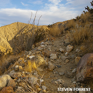 |
Alcoholic Pass Book References Hiking in Anza-Borrego Desert V.1 Page 36 Anza-Borrego Desert Region Pages 22,85-86,128 Alcoholic Pass will give you a moderate workout, 4.6 miles roundtrp, 800 feet of elevation game, not too far from town, with the reward of a beautiful saddle at the top, where you can gaze down on Coyote Creek on the west side and Clark Dry lake on the east. The trail had its start as a Cahuilla trail from the Los Coyotes Indian Reservation to Clark Dry Lake. Early Cattlemen Frank and Fred Clark used the trail too, as a direct route from The Clark Valley to Coyote Canyon. The unusual name has no certain origin, although it is said that the name came into use because Cowboys felt drunk by the time they got off the trail. How to Get There From Christmas Circle go east on Palm Canyon Drive (S22) for .5 miles and turn left (north) onto DiGiorgio Road and drive for 4.7 miles to the point where the pavement ends and a dirt road continues straight ahead into Coyote Canyon. This is one of the most heavily travelled dirt roads in the park and is normally in good condition for the first few miles. Continue straight ahead for 2.4 miles and look for the Alchoholic Pass trail marker on the right side of the road. |
|||||||||||||||||||||||||||
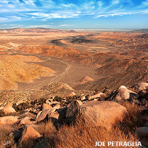 |
Sombrero Peak Book References Hiking in Anza-Borrego Desert Volume 2, Pg. 153 Anza-Borrego Desert Region, Pgs 222-223 The route tostrong class="auto-textBold16"> Sombrero Peak is a fairly short 1.5 miles but you climb 2000 feet over the boulder covered slopes to get there. At the top you are rewarded with wide views across southern California and into northern Mexico. a place that is mentioned in several different sections of this guide because it offers so much and is easy to get to with any kind of vehicle. For photographers, the wind and water eroded rock has created many beautiful formations and shapes and is a great place for creative photography. If you do not have a vehicle for dirt roads you can park just off of the highway and explore on foot. Whether you drive or walk, after less than a mile the road forks and either the left fork or straight ahead leads to more interesting rock formations. The area is small enough, expecially if you drive, to check out both forks. The dirt road itself tends to be firm and not too sandy so if you have a vehicle with high enough clearance to go over rocks in the road you should be OK. That said, road conditions can change quickly, so don't get into a situation that either the vehicle or the driver cannot handle. Another option is to drive to the fork and explore on foot from there. How to Get There From Christmas Circle drive south on Borrego Springs Road for approimately 5. 2 miles to the junction with Yaqui Pass Road (S3). Turn right onto S3 and continue for 6.2 miles, past the Tamarisk Campground to the junction with Highway 78. Turn left onto Highway 78 and go 7.2 miles to the junction with Highway S-2, The Great Southern Overland Stage Route, and turn left. Continue on S-2 for 29.2 miles to the Indian Gorge Jeep Road, and turn right. Road conditions can vary, and 4WD is recommended but the road is often passable to most high clearance vehicles. Drive for 2.8 miles and park at the end of the road. From the end of the road climb straight up the ridge to the south until you reach a flat spot, then continue to the west, and then southwest to the boulder covered summit of the mountain. Take note of your route up so you can go back the same way. |
|||||||||||||||||||||||||||
 |
||||||||||||||||||||||||||||
|
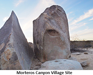
Morteros Canyon Book References Hiking in Anza-Borrego Desert Volume 1, Pg. 95 Anza-Borrego Desert Region, Pgs 232,233,235,257,258 The first part of the Morteros Canyon hike is relaxed stroll, just .2 miles to the site of a prehistoric Kumeyaay village. But don't be misled by this easy going part, the remaining 2.8 miles round trip are strenous, and several places will require careful boulder scrambling. There are lots of desert plants along the way and the end of the route, where the canyon drops off sharply, you will have views to the Vallecito State Station and the Laguna Mountains. As you get started, spend some time exploring the village site, there are many morteros and metates ground into the rocks were food has been prepared. How to Get There From Christmas Circle drive south on Borrego Springs Road for approimately 5. 2 miles to the junction with Yaqui Pass Road (S3). Turn right onto S3 and continue for 6.2 miles, past the Tamarisk Campground to the junction with Highway 78. Turn left onto Highway 78 and go 7.2 miles to the junction with Highway S-2, The Great Southern Overland Stage Route, turn left and go 5.7 miles to the Blair Valley turnoff on the left side of the road. The Blair Valley road, and dirt road conditions can often change, but this road is often good enough for high clearance vehicles. 4WD is always advised. On the Blair Valley road drive east and then south for 1.2 miles along the base of the hills until you come to an arrow directing vehicles to go to the right. Go another 1.7 miles to a fork, turn left, go another .2 miles and then left again to a parking area on the right side of the road. To start your hike, follow the well-used trail to the village site, then stay to the left and continue walking down the canyon towards the south. After 1.2 miles there are several large boulders overlooking the area where the canyon drops off sharply. This is a good place to stop, enjoy the view, and return the same way that you came, |
||||||||||||||||||||||||||||
|
Learn More about this topic With books, maps, and guides from the ABDNHA Desert Nature Center Store 652 Palm Canyon Drive, Borrego Springs, CA 92004 Visit us in person or shop online. Select "Pickup" as your shipping method and pickup your items when you arrive with no shipping fees. |
||||||||||||||||||||||||||||
|
|
||||||||||||||||||||||||||||
|
||||||||||||||||||||||||||||


