|
Anza-Borrego North Geology: Borrego Badlands
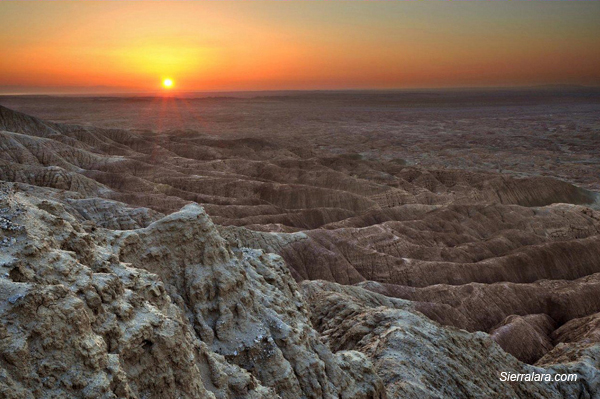
Sunrise over the Borrego Badlands
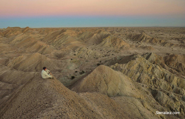
Solitude in the Borrego Badlands
The Borrego Badlands extend northward from Highway 78 in Anza-Borrego Central
to the Santa Rosa Mountains in Anza-Borrego North.
Caution: Unpaved roads and their roadsides
in the Borrego Badlands area can be extremely sandy. Four-wheel drive is
always recommended, sometimes mandatory, when you leave the pavement.
Access points from County Road S-22 (Pegleg Road and Borrego-Salton Seaway)
include the following:
- Old Springs Road
- This short road to the county dump leads to jeep trails (4WD only)
which can be driven or hiked to points in the Borrego Badlands, including
Mammoth Cove, Inspiration Point, and Borrego Sink. More.
- Beckman Wash (North)
- This jeep trail is a right turn (south) off the Borrego-Salton Seaway
at mile 27. The road sign is several yards from the highway. The road
leads southward to the badlands, then turns westward. The road here is
quite narrow for several yards. It then goes past Mammoth
Cove and a turnoff to a Bishop's Tuff deposit, to the Pegleg Road
stretch of S-22.
- Inspiration Wash
- This jeep trail goes south to Inspiration Point, then west to the county
dump and Pegleg Road. More.
- Fonts Wash
- The 5-mile drive to Fonts Point is one of the area's most popular,
especially to watch the sunset or (to a lesser extent) the sunrise. Drive
carefully, however. The sands can be deep and difficult. More.
- Thimble Trail - Short Wash - Vista del Malpais
- This jeep trail from mile 31.9 crosses and passes several fault scarps.
It ends at Short Wash which extends from Font's Wash on the west to Palo
Verde Wash to the east. Turn east at Short Wash to reach the popular Vista
del Malpais.
- Palo Verde Wash
- Palo Verde trees beside S-22 mark the start of the Palo Verde Wash
jeep trail which bends southward into the Ocotillo Wells State Vehicular
Recreation Area. The trail is joined by Ella Wash and Short Wash.
- Truckhaven Rocks
- North of S-22 at the foot of the Santa Rosa Mountains.
- Call Box S22-364
- A short circular drive here affords views of the Borrego Badlands from
your car.
- Ella Wash
- A short sandy trail from the Borrego Salton Seaway to Palo Verde Wash
at the edge of the Borrego Badlands. More.
- Arroyo Salado Wash
- Begins with a primitive camp off the Borrego-Salton Seaway. Continues
to Truckhaven Trail, Seventeen Palms, and south to Highway 78. More.
- Calcite Mine Road
- Departs the Borrego-Salton Seaway opposite Call Box S22-382. Crosses
the South Fork of Palm Wash and continues 1.5 miles to the former Calcite
Mine. Caution: High-clearance 4WD only. More.
- Palm Wash (North Fork and South Fork)
- Palm Wash extends from below the Calcite
Mine to the Salton Sea. The South Fork
has some notable concretions within walking distance of the Calcite Mine
Road and ends at a slot canyon. The North Fork can be hiked to some sheep
tanks.
- Truckhaven Trail
- The section leaving the Borrego-Salton Seaway at Call Box S22-382 leads
to a remarkable area of concretions known as Cannonball Wash. More.
- Tectonic Gorge
- In Ocotillo Wells State Vehicular Recreation Area, off the Borrego
Salton Seaway at Cut Across Trail. Leads westward to the Borrego Badlands.
Outstanding concretions. More.
|
|

|
|
|