Central Anza-Borrego: Fish Creek Wash
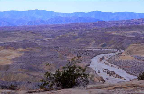
Fish Creek Wash as SeeN from the Wind Caves as it Winds Westward
Fish Creek is synonymous with geology and long drives across the badlands.
While the creek itself has been dry for many years, in its day it drained
the Vallecito Mountains and carried water east to the Salton Trough.
Fish Creek once ran through a tropical savannah over which roamed pre-historic
animals who are known to us today only through their fossilized bones in
the soil. At various other times, the salt waters of the Gulf of California
and the fresh water of the Colorado River Delta made appearances in the
area. The changes of scene and shifts in the landscape were marked by volcanoes,
powerful earthquakes, and giant landslides.
Visitors today follow Fish Creek Wash on a jeep trail that begins west
of Split Mountain Road 8 miles south of Ocotillo Wells. A couple of things
to note:
- The sand in Fish Creek Wash can suddenly become soft following a storm,
and there are boulders in the road. Four-wheel drive is always recommended.
- After you pass through Harper Flat about 22 miles up the road, you come
to the bottom of the Pinyon Mountain Dropoff which is one way from west
to east. In other words, this is as far as you go.
Here are some points of interest:
Fish Creek Mountains – These mountains are on your
left as you pass through Split Mountain Gorge. They bend to the southeast
for several miles to Carrizo Gorge which is best known as the Southern
Emigrant Trail. Split Mountain Road ends at the United States Gypsum
Corporation quarry which is off limits to the public.
A jeep trail to the east off Split Mountain Road (EC 085) can be followed
through 4-wheel drive country for about 25 miles to Plaster City.
Fish Creek Camp – About a mile and a half from Split
Mountain Road, just before you enter Split Mountain Gorge, Fish Creek Camp
is on hard ground on your left. It can be a good place to spend the night.
Vallecito Mountains – These mountains are on your
right as you pass through Split Mountain Gorge
and extend westward to the peninsular ranges. Whale Peak, the high point
in the Vallecito Mountains, will be visible as you travel through the Fish
Creek Wash area.
Wind Caves – On your
left after you leave Split Mountain Gorge. Park and hike a short trail for
spectacular views of the badlands.
North Fork Fish Creek Wash
– On your right after you leave Split Mountain Gorge.
Elephant Knees –
On your left as Fish Creek Wash turns westward. One of geology's spectacular
formations.
Loop Wash – As the name implies, Loop Wash goes
north from Fish Creek Wash at the signature coquina-shell beds atop a hill,
then turns west toward an area studied for its petrified wood, and then
turns south again to rejoin Fish Creek Wash. It is less travelled than Fish
Creek Wash.
Camels Head Wash –
Runs south of Fish Creek Wash between the east and west entrances to Loop
Wash. Ends at East Mesa.
Layer Cake – A geological
exclamation point!
Sandstone Canyon – Aptly
named and a favorite destination. It's possible to hike out of this canyon
and west to June Wash. If you do that, good maps are advised — the
Arroyo Tapiado and Agua Caliente Springs maps of the USGS 7.5-minute series.
|