The desert and mountains
that you see today in Anza-Borrego were the homes of native people as long
as 12,000 years ago. These early people depended upon the land for
everything they needed. They would move from one area to another
during the year so they could find the plants and animals they needed for
food. There are many places in Anza-Borrego where you can discover
evidence of the native people who lived here.
1. Anza-Borrego State Park Visitor Center
25 Points in your Exploring Guide!
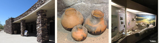
The State Park Visitor Center is in Borrego Springs and has excellent
exhibits about the native people of Anza-Borrego, with many artifacts on
display.
Don't pick
anything up or disturb the soil in any way .
Do not leave
your mark on anything.
Take pictures
and memories!
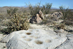
The ancient Kumeyaay village site in Mine Wash is an excellent place
to visit if your parents are comfortable driving on a dirt road.
The turnoff into Mine Wash is on the south
side of Highway 78 about 3 miles east of the Tamarisk Grove
Campground. The
village site is right along Mine Wash and a park sign marks the spot.
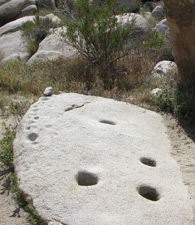
Many morteros are scatted among the large
boulders. There is no
hiking involved; you can move through the large rock formations just
yards from your vehicle.
4WD is not generally required for the route to
the village site but high clearance is advised.
Both of these trails are
in the Blair Valley. The Mortero Trail ( .5 miles
roundtrip) begins 3.5 miles from Highway S2. Numerous morteros can be
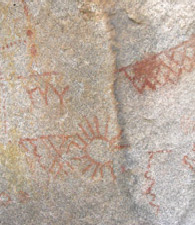
seen along the trail. The Pictograph Trail ( 2 miles
round trip) starts 3.6 miles from Hwy. S-2. This trail is easy walking and
leads to a large boulder that has many pictographs. Download the
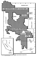
State Park Map at the top of this page or pick up a map locally if you are
not sure of the location.
What do you think it would be
like if you lived at these places in the desert?
What do you think boys and
girls your age did when they lived here?
What would lunchtime be like
for the boys and girls who lived here?
Need Directions or
Additional Information?
Stop by the ABDNHA Nature Center, 652 Palm Canyon Drive,
just one block west of Christmas Circle, when you are in Borrego Springs.