|
<<
Back to The Sand Paper Index Page
|
 |
Hiking Santa Ysabel Preserve East
By Sanjiv Nanda
This article was originally published in The Sand Paper, the membership
newsletter of the
Anza-Borrego Desert Natural History Association |
|
|
We are fortunate in San Diego County that day hike
destinations are a short drive away. If you can go on a weekday, there are
many hikes where you will be rewarded with peace and solitude, even as
cabin-fever is driving up visitations to popular hiking spots on weekends.
One wonderful and lightly visited hiking destination that I would
like to recommend is the Santa Ysabel Preserve near the corner of Highways
78 and 79 in Santa Ysabel. A new backcountry Nature Center that opened in
December provides an overview of our region’s history, geology and
habitat. It’s air conditioned, and so a welcome spot for a post-hike cool
down to check out the exhibits and use the clean restrooms. Pre-hike, a
modern water fountain is designed to accommodate your water bottle. A
ranger is available to answer questions and provide hiking tips. |
| |
|
 |
There are two parts to the preserve and at least four separate places to
park and hike. Most of the preserve is donated ranchland, and the hiking
trails are old ranch roads. Many trails and hiking loops should be
characterized as steep and moderately strenuous. A little later I will
mention a couple of easy hikes as well.
The newest trail begins
right behind the Nature Center and immediately starts on a steep uphill
climb on a historic dirt track that was part of a trail used by pioneers
to drive cattle from Santa Ysabel to Julian. It climbs over 500 feet in
elevation over the first mile. Before you start on the hike, I recommend
that you take a picture of the trail map on your smartphone or remember to
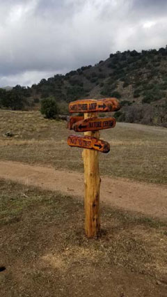
carry the preserve’s brochure with the trail map. Distances and turnoffs
are clearly marked. Beautiful trail signs were completed by a volunteer
woodworker in time for the grand opening of the Nature Center.
Our
hike this summer was about 4.5 miles with over 850 feet of elevation gain
and loss. We chose to go out and back on the trail behind the Nature
Center (one mile each way) and complete a 2.6-mile loop using portions of
the Coast to Crest and Santa Ysabel Loop trails. There are many other
interesting options, but note, most of them involve steep climbs. A hiking
stick comes in handy.
|
| |
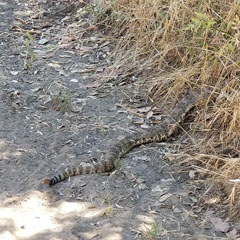
| As we hiked, we saw hawks and turkey vultures circling
overhead, and heard the tap-tap-tap of woodpeckers on the pine trees. A
large rattlesnake was blocking the right half of the trail. We waited
patiently. Only after it moved off the trail and was hidden in the brush
did it let off its eponymous rattle that lasted almost a minute and
indicated the seriousness of the situation. We felt that the rattler’s
complaint wasn’t fair, the warning should have been delivered to us as we
approached, not after we had already paid our respects. |
| |
As we hiked, we saw hawks and turkey vultures circling
overhead, and heard the tap-tap-tap of woodpeckers on the pine trees. A
large rattlesnake was blocking the right half of the trail. We waited
patiently. Only after it moved off the trail and was hidden in the brush
did it let off its eponymous rattle that lasted almost a minute and
indicated the seriousness of the situation. We felt that the rattler’s
complaint wasn’t fair, the warning should have been delivered to us as we
approached, not after we had already paid our respects.
|
 |
|
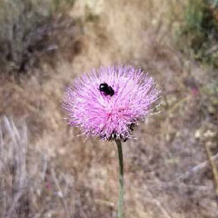 |
Bees appeared to have their choice of blooms, in different colors, and I
assume varying taste and flavor of nectar: thistle, and purple and yellow
varieties of Mariposa lilies, among many other blooming plants, including
profusions of white and pink flowers on the native manzanita.
|
|
|
|
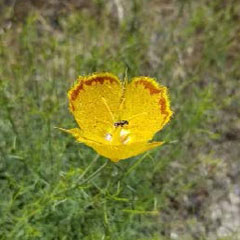
The highlight of the hike for me were the singularly attractive flowers of
the yellow Mariposa Lily with brown markings on the tips of the petals.
Interestingly, for this variety, we found that more of the blooms had
opened up on our way back after noon than in the morning.
|
 |
| |
An easy to moderate hike
with minimal elevation gain in the preserve is accessed from the Farmer
Road Parking Area. From Wynola Road, head north on Farmer Road, the Santa
Ysabel Preserve East parking area is a little over a mile on the left side
of the road. A moderate 1.5-mile hike brings you to your destination, the
stream crossing of Santa Ysabel River. Mature oaks and sycamores provide
shade on this hike and at the stream crossing. The round trip is 3 miles.
Across the stream, a steep trail connects to the Coast to Crest Trail and
the Kanaka Loop Trail.
*WHEN YOU GO
Santa Ysabel East Preserve
Hours: 8 a.m. to sunset, 7
days a week
Santa Ysabel Nature Center
22135
Highway 79, Santa Ysabel, CA
April - October: Mon Thurs 10–6; Fri–Sun
9–7
November - March: Mon–Thurs 10–5; Fri–Sun 9-5
*Be sure to
check open days and hours, as they may have changed.
|
Text and photos by Sanjiv Nanda
|
Sanjiv Nanda
is a hike leader and a member of ABDNHA's Board of Directors.
© Anza-Borrego
Desert Natural History Association (ABDNHA), The Sand Paper, Fall 2020.
|
|
|
|
|

|