|
<<
Back to The Sand Paper Index Page
|
 |
A Better Name for Alcoholic Pass?
By Bill Sullivan
This article was originally published in The Sand Paper, the membership
newsletter of the
Anza-Borrego Desert Natural History Association |
|
|
|
|
When you think about it, Alcoholic Pass is a bad name. It references a
human failing when it well could be a monument to the ingenuity of the
Cahuilla people who once had great success hunting and gathering here.
In Coyote Canyon, when you climb from Desert Gardens and look around and
put yourself into the agave moccasins of the Cahuilla, what they did is
something to think about.
Sure the trail winds this way and that, just like a drunk, which is one
reason given for the name. Its full of switch-backs. It doesnt cover
much ground as the crow flies, but any crow who tried to follow it would
quickly become a cuckoo.
But remember who created it.
|
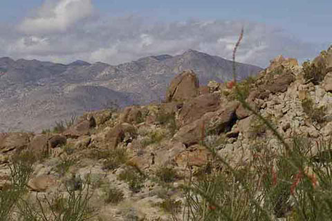
Alcoholic Pass Trail |
It was Cahuilla women carrying heavy loads of roots and seeds or ollas of
water. It was Cahuilla men, perhaps a band of lucky hunters returning to camp
with a sheep or deer. Note also that the winding of the trail minimizes its
steepness and makes it easy to climb. Besides, it is always a pleasure to stop
for breath and turn around and enjoy the view.
 |
Before you leave Desert Gardens,
take a look around. David Prescott Barrows refers to Coyote Canyon as a
veritable harvest field for the Indians, and Desert Gardens is prime
territory. The Cahuilla women, the primary gatherers, learned at a very early
age how to make the most, food-wise, out of desert plants. They learned how to
harvest the buds and fruit of cactus. They learned how to grind the seeds of
such plants as mesquite, ocotillo, and other plants too tiny or seemingly
inconsequential to notice. They learned how to make food out of the roots of
arrow weed and agave. They turned creosote bushes into medicines.
We can assume that women from the village near Clark Dry Lake used this trail
to come to Desert Gardens (and beyond) to harvest the plants and shrubs. After
a day of gathering, they would load the seeds, buds, and blossoms into baskets
and carry them up, over the trail, and home again.
And then there were the hunters. The Cahuilla men, young, nimble, and quick,
used the route to get to up on the Coyote Mountain ridge where they could hunt
large game like sheep and deer. Quite possibly, when an all-male hunting party
was busy up on the ridge, the women would fill their ollas at Coyote Creek and
bring them water.
At the top, the trail goes through a flat area between rises in the ridge.
Rocks on the ground appear to have been cleared away as if for sleeping.
Perhaps hunting parties spent the night here before taking off at dawn. Lester
Reed points to the existence of a trail to Hidden Springs about 3 miles north
where, as Jerry Schad points out, another trail can be taken back to Lower
Willows by way of Box Canyon.
This trail would have been used for longer expeditions as well. In late summer
or early autumn, people from west-side villages in Coyote Canyon would have
crossed over to Clark Valley to climb into the Santa Rosas in search of the
nuts of pinyon pines on top of Villager and Rabbit peaks. As hikers cross the
top of the ridge, the trail leads northeast to where Rabbit Peak, at 6623
feet, looms above. In the years of Lake Cahuilla, specifically from about 800
to 1600 A.D., it seems likely that the Cahuilla of Coyote Canyon could have
gone east and traded for the fish caught by the Cahuilla of that area. Trading
expeditions would have set out across Alcoholic Pass and up into the mountains
where trails lead to the east. [Anthropologists estimate that the Cahuilla
arrived here sometime between 1000 A.D. and 1000 B.C.]
Use of Alcoholic Pass wasnt all business. Lowell John Bean and Katherine Siva
Saubel tell us that agave, or Century Plant, was a basic food staple and agave
harvesting was primarily a masculine activity and also a festive time. Might
not the Cahuilla of one village have invited the Cahuilla of other villages to
share the festive spirit with them?
* * *
To get there. From Christmas Circle, drive east on Hwy S-22 and turn left
(north) on DiGiorgio Road toward Coyote Canyon. The trailhead is on the right,
2.4 miles past the end of the blacktop. Or, drive east on Hwy S-22 past the
airport and the Pegleg monument and turn left (north) on Rockhouse Canyon
Road. The trailhead is on the left, 8.4 miles after you leave Hwy S-22. The
Clark Valley approach does not involve the steep climb of the Coyote Canyon
approach, but it is a much longer walk up a wash without a trail.
© Anza-Borrego Desert Natural History Association, from the ABDNHA member
newsletter The Sand Paper.
|